Rectangular Cartesian Coordinates in 2-Dimensions
Free
About This Course
This topic equips learners with the basics of the Cartesian plane, enabling them to identify coordinates, plot points, and interpret graphs. Real-world mapping, navigation, and graphical data representation are integrated for practical application.
Learning Outcomes:
The learner should be able to:
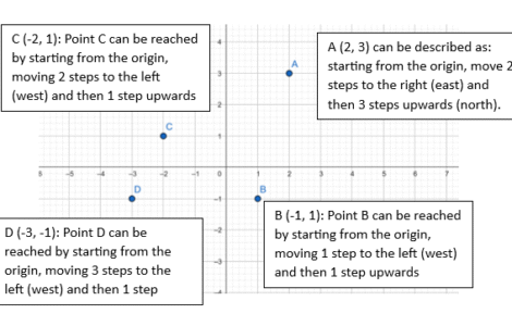
- draw and label the Cartesian plane.
- identify the x– and y-axis.
- read and plot points on the
- Cartesian plane/coordinate grid.
- complete shapes on a coordinate grid.
- choose and uses appropriate scale for a bi-variate data set.
- works out real-life problems involving percentages.